Mapping in Freycinet, Huon and Tasman Fracture Marine Parks and outside-park reference areas to underpin biological surveys
Where
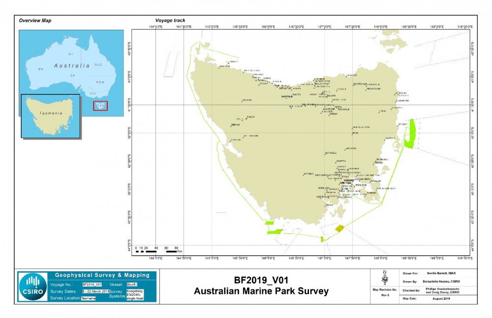
Tasman Fracture, Huon and Freycinet Marine Parks, South-west Cape and Pedra Branca.
Who
IMAS/CSIRO/Geosciences Australia
When
March 8th-22nd 2019
Why
Mapping of shelf waters in and adjacent to marine parks is an essential first step to understanding the nature and extent of habitats found within them, particularly biodiversity-rich features such as rocky reef.
Once the location and nature of these habitats is known, this information can be used to underpin more targeted inventory and monitoring of the biodiversity values found within the parks, which in turn better informs the management of them by Parks Australia.
Where information is needed on the effectiveness of marine park protection relative to adjacent waters, it is important that monitoring programs include a matching contrast between responses in and out of parks in similar habitats. Hence, this mapping program included areas outside of marine parks to act as suitable reference habitat.
How
The mapping was undertaken from the University of Tasmania vessel "Bluefin" using a Kongsberg EM204c multibeam echosounder provided by Geosciences Australia. This system allows the seabed to be mapped with full 3D coverage, with a pixel density of processed data at around 2 x 2 metres. The multibeam system was operated by CSIRO Hydrographic staff with IMAS support.
Data was acquired along transits as well as in the survey areas, to contribute to the overall acquisition of seabed coverage in Australian waters. The acquired data was post-processed by CSIRO and provided as a range of survey outputs, including a detailed survey technical report, multiple-scale maps of survey areas, and final data in Computer Aided Research Information System (CARIS) and Geographic Information System (GIS) geospatial data formats. This information is held by IMAS, CSIRO and has been contributed to AusSeabed (via Geosciences Australia) for open access.
Detailed geotiff images containing georeferenced information about each mapping area have also been supplied to the Environmental Resources Information Network (ERIN).
What did we learn?
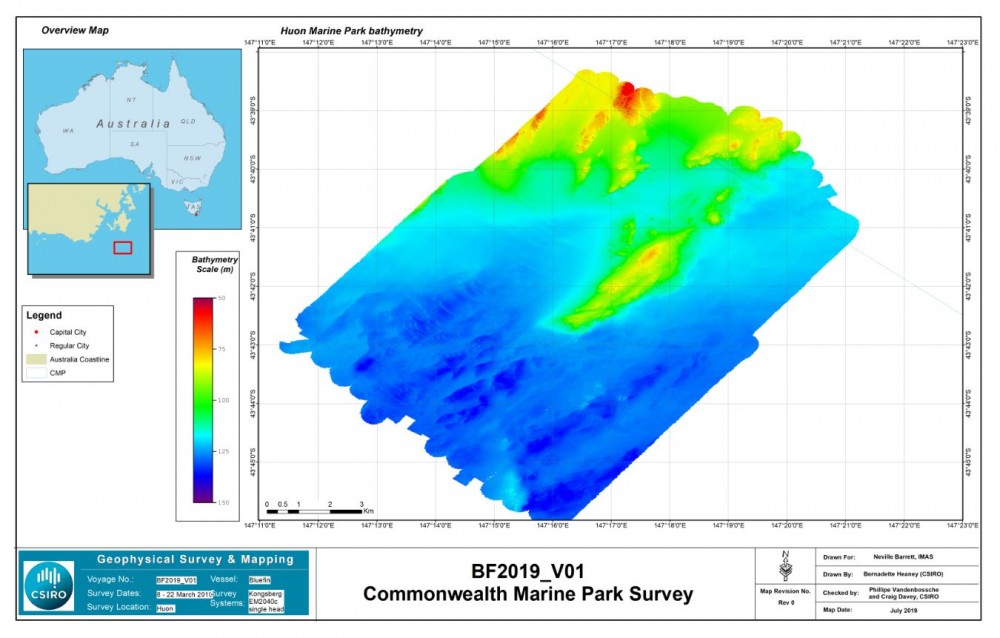
The mapping program was primarily focused on two objectives: detailed mapping of the Freycinet Marine Park, and mapping to identify suitable reference habitat to underpin future monitoring within the Tasman Fracture Marine Park. As the shelf waters of the Huon Marine Park are close to the Tasman Fracture Marine Park and share similar shelf reef habitats (but with different levels of protection), the work involved mapping within the Huon Marine Park as well.
This project has significantly increased our understanding of the nature of shelf habitats in all three parks as part of this process. We have now mapped more than half of all shelf waters in the Freycinet Marine Park, including all of the shelf-break to 300 metres. This has revealed that drowned relict coastal dune systems are extensive throughout the park, while small canyon incisions provide a series of isolated reef systems at the shelf-break.
These isolated reefs are actively targeted for fishing of highly prized striped trumpeter. Mapping within the Huon Marine Park has revealed an extensive region of complex reef in the north-east corner of the park, extending to around 100 metres before grading to sandy substrate. This reef underpins a significant lobster fishery in the region.
Mapping in the Tasman Fracture Marine Park has significantly increased existing understanding of that area, indicating that while much of the park contains soft-sediment habitats, there is a small extent of reef along the north-western boundary that extends to depths of 140 metres.
This new information will assist the management of these marine parks as habitat distribution and how it influences user distribution is now better understood. Park managers also now have a sound set of mapped external and internal locations to inform future biological monitoring within the three marine parks.
What next?
There are a two main next steps:
- Complete mapping of shelf waters in the marine parks:
- Freycinet Marine Park: approximately three days mapping (at 24h/day) will be all that is needed to complete mapping of Freycinet Marine Park shelf waters.
- Tasman Fracture Marine Park: the majority of shelf waters have now been mapped, approximately two days (at 24h/day) are needed to complete mapping along the shelf-break to determine if any shelf-break reefs are present in this marine park. An initial examination of the south-west region of the park's shelf-break during this survey found the more promising areas for outcropping reef to be completely soft-sediment.
- Huon Marine Park: a more extensive mapping program is required as little of this park has been mapped so far. Approximately seven days of 24/h/day mapping would complete shelf to shelf-break coverage.
- The second step is to implement a biological inventory and monitoring program within these marine parks based on the acquired knowledge of habitat distribution.