Where
Apollo Marine Park
Who
Deakin University in partnership with iXblue and Parks Australia
Crew: Associate Professor Daniel Ierodiaconou, Sam Wines, Paul Tinkler
Data processing: Dr Mary Young, Dr Stephen O'Brien
When
January 2020
Why
Researchers believe areas in and around Apollo Marine Park are an important hotspot for marine biodiversity, including habitats supporting deep water corals, sponges, fish communities and commercially important rock lobster. Mapping of these waters is an essential first step to understanding the nature and extent of habitats found within them, particularly biodiversity-rich features such as rocky reefs.
The initial voyage provided critical baseline information that will allow marine park managers to develop a habitat inventory of the park and learn more about its unique biodiversity values.
Similar to maps on the land generated by satellite pictures, sonar maps provide detailed imagery of the seabed that can be used to identify potential areas of ecological significance and helps to target future biodiversity surveys. The imagery also provides a glimpse into our geological past.
How
The survey was conducted onboard Deakin University's research vessel MV Yolla using a Kongsberg EM2040C multibeam echo sounder. The MV Yolla scanned more than 872 kilometres of seabed within the marine park, which equates to more than 119 square kilometres of mapped seabed or ten per cent of the marine park.
At a survey speed of ~6 knots, the MV Yolla uses approximately 10-20L of fuel per hour making it one of the most environmentally friendly platforms for seabed mapping in Australia. The EM2040C was operated at a frequency of 300 kHz with water column logging on with approximately 30% overlap of runlines.
The acquired data was post-processed by Deakin University and iXblue and is held by Deakin University and has been contributed to AusSeabed (via Geoscience Australia) for open-access. The bathymetry and backscatter data (indication of seabed softness or hardness) were used to provide an interpretation of the seafloor geomorphology.
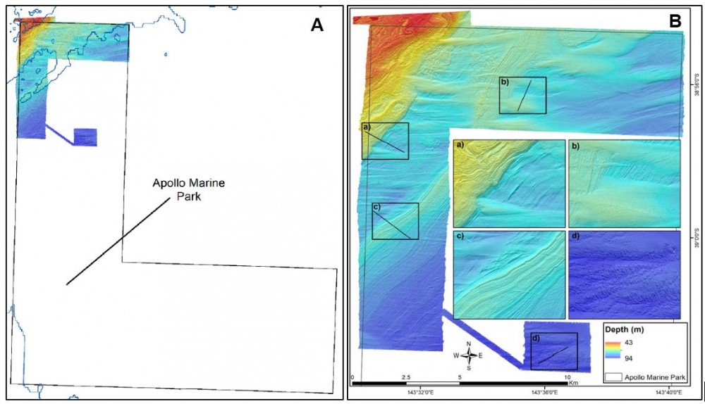
Figure 1: (A) Apollo Marine Park and area mapped by Deakin University. (B) Bathymetry of the north-west corner of Apollo Marine Park with colour representing depth. Four features are highlighted in figures a, b, c & d. The black lines indicate where a profile of the seabed was derived (Credit: Deakin University)
What did we learn?
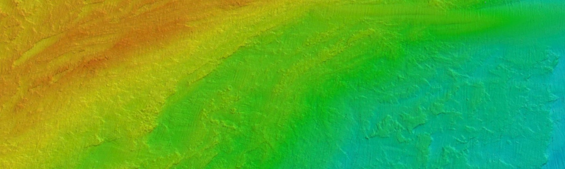
The latest mapping data reveals fine scale seabed features and habitat characteristics, ancient shorelines and river systems that would have flowed when the sea level was lower, many thousands of years ago. The data shows an extensive region of reef and hard bottom in the north-west corner of the marine park.
This reef extends from Victorian waters is likely to support the local lobster fishery. This work provides insight into the habitats that are likely to support biodiversity rich communities.
This type of information will help us to more effectively manage the marine park and prioritise biological sampling such as baited camera systems, towed video and autonomous underwater video.
The wreck of MS City of Rayville, the first American ship to be sunk during WWII, also lies within Apollo Marine Park. During the voyage, the research team took the opportunity to gather some detailed information about the American freighter which will feed into future preservation efforts.
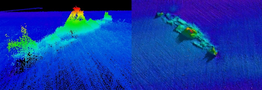
Figure 2: Depth profile of the City of Rayville shipwreck situated on the western edge of Apollo Marine Park (Credit: Deakin University)
What next?
The seabed mapping data provides an important baseline for the Apollo Marine Park and will enable future targeted biological surveys on mesophotic reefs identified in these surveys.
These reefs are likely dominated by sessile invertebrates including high diversity sponge assemblages, bryozoans, sea tulips, hydroid fans and octocorals as observed in mapping efforts in state waters north of the park. They are also likely to support diverse temperate fish communities.
These maps can be used to help inform ground truthing of habitat types. The data also provides important insights to sediment transport around Cape Otway and a glimpse into our geological past with preserved submerged shorelines that will help inform shoreline evolution and management of our present-day coastline.
Related data and publications:
Ierodiaconou D, Young M, O’Brien S (2020) Hydrographic Survey of Apollo Marine Park. Final report to Parks Australia, Warrnambool, May. CC BY 4.0