Over the last decade scientists at the Institute of Marine and Antarctic Studies (IMAS) have been using an autonomous underwater vehicle (AUV) to conduct photographic surveys of seafloor (benthic) communities in Australian Marine Parks (AMPs) across the South-east Marine Parks Network (the SE Network). This project used this imagery to provide the first description of the biological communities across these marine parks and how they have changed over time.
Where
Huon, Freycinet, Flinders and Beagle Marine Parks at selected sites where repeat surveys were conducted.
Who
IMAS, Australian Centre for Field Robotics, University of Sydney, International Marine Observing System (IMOS)
When
Repeated surveys using an AUV were conducted in Huon Marine Park in 2009, 2010 and 2014; Freycinet Marine Park in 2010, 2011, 2012, 2014 and 2016; Flinders Marine Park in 2011, 2013 and 2017; and Beagle Marine Park in 2017 and 2018. Annotation of the imagery and statistical analysis was conducted in 2020.
Why
Knowledge of the biological communities that inhabit deep shelf habitats (40 m to approximately 200 m) and how they change through time is currently limited due to the technical difficulties with surveying these waters.
Understanding the distribution of species, their abundance and how variable they are through time is crucial information for scientists and managers who are interested in monitoring these systems.
This information can be used to decide what species or groups should be tracked through time (termed as “indicators”) and to help design the ongoing monitoring of changes due to management actions or external pressures occurring across marine parks.
How?
Photographic surveys of the seafloor were conducted using an AUV. The AUV navigates a pre-programmed flight path and takes continuous overlapping images of the seafloor while maintaining a constant altitude. The resultant imagery was the first detailed in situ examination of the benthic (seafloor) biological communities that inhabit each of the marine parks, providing unique insights into the habitats and biological communities present.
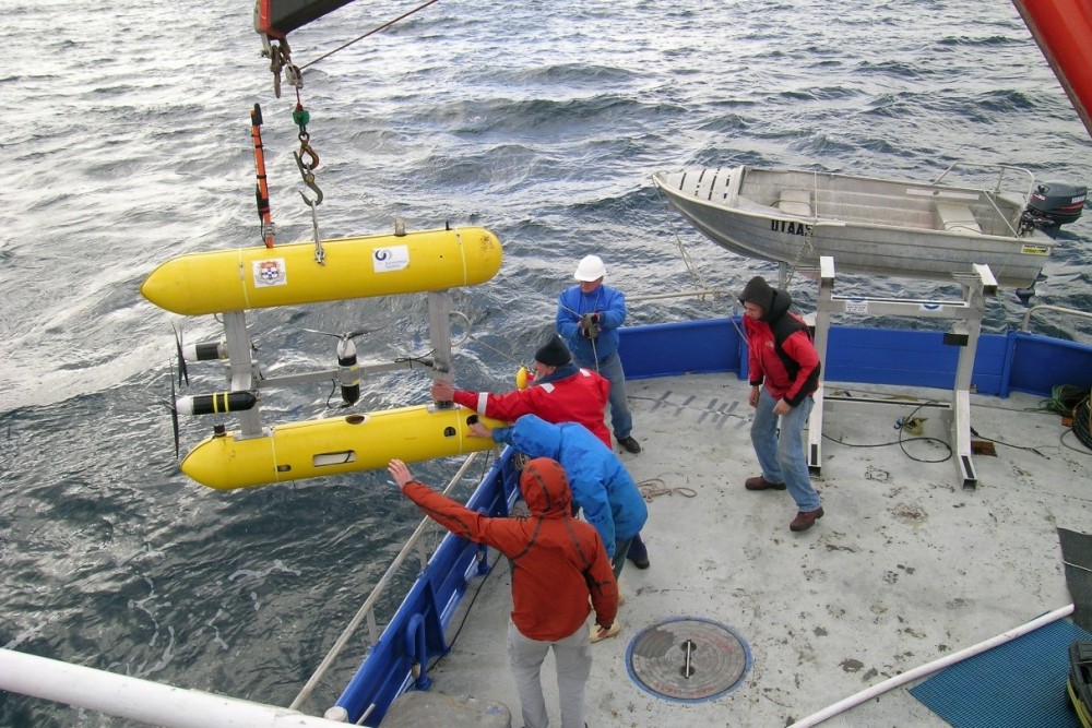
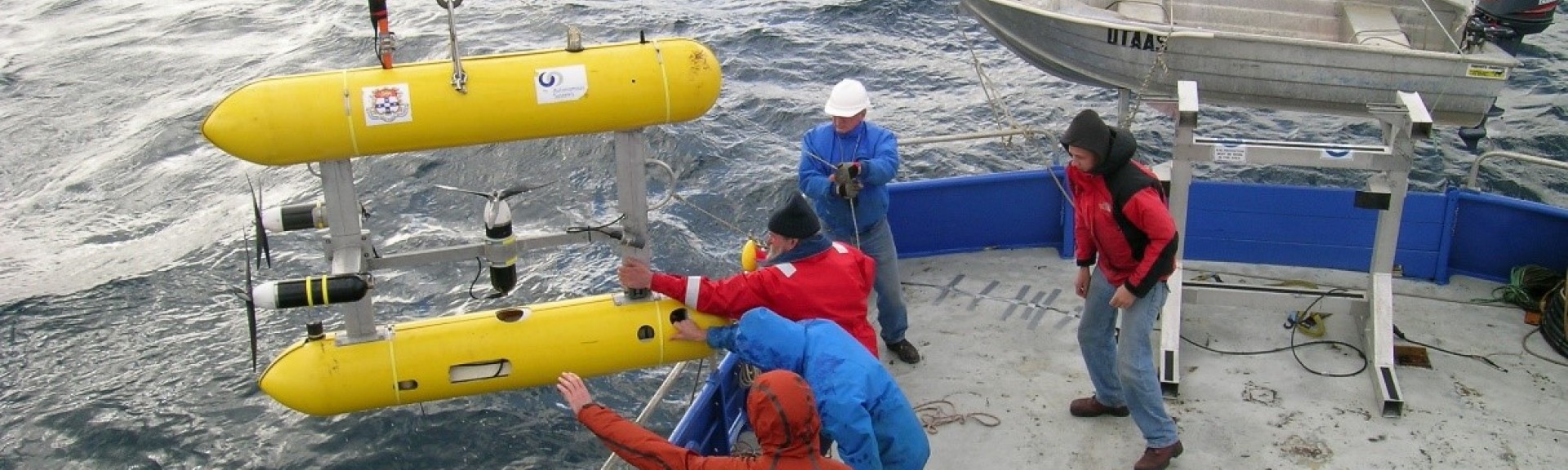
The AUV Sirius being deployed for a survey. Image credit: IMAS
AUV deployments were underpinned by multibeam echosounder surveys conducted prior to the initial AUV surveys within each marine park. This allowed the selection of sites that included a significant proportion of hard-bottom rocky reef habitat that is known to be important as substrate for attachment and growth of many invertebrate species.
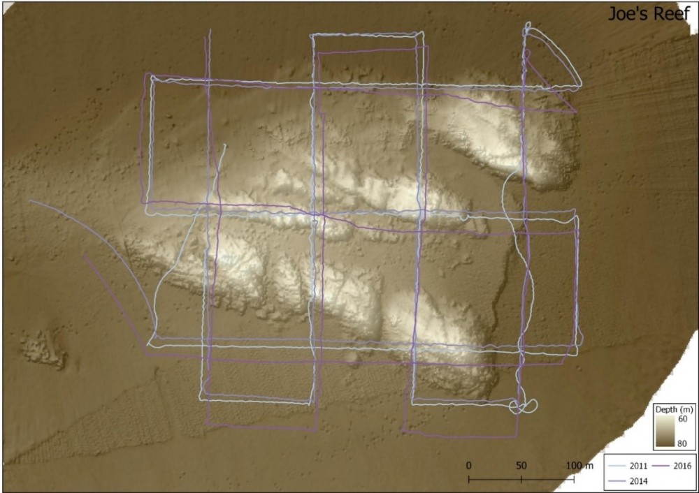
Track lines of AUV surveys conducted at Joe’s Reef in Freycinet Marine Park in 2011, 2014 and 2016. Underlying shading shows the reef structure derived from multibeam mapping. Image credit: IMAS/IMOS
The AUV imagery was turned into quantitative information through scoring by trained scientists. A random selection of images was taken from each repeat survey and random points were overlain on the images. The biota under each point was classified into a distinct “morphospecies” (morphologically distinct grouping), so that a percent cover (a measure of abundance) of each morphospecies could be calculated for each year at each repeat site. Also, more intensive scoring of total abundance was conducted for a subset of morphospecies to allow a comparison of approaches. The time series of cover was then analysed using statistical models to detect trends and estimate variability. Simulation studies were also conducted to test the ability of ongoing monitoring to detect change under a variety of future scenarios.
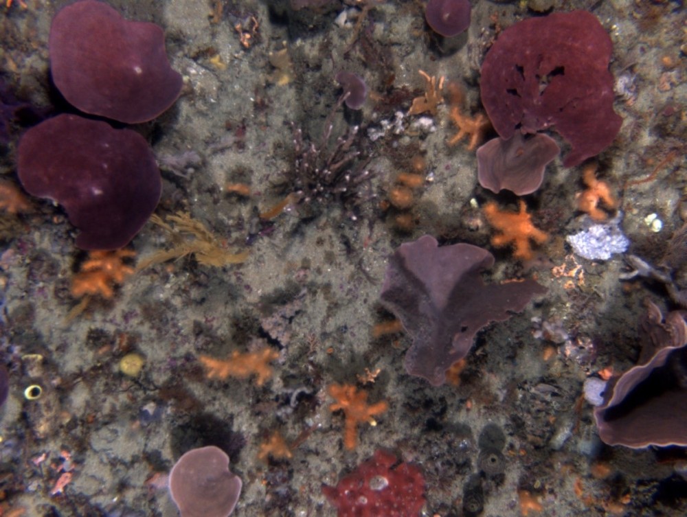
A seafloor image captured by the AUV in Flinders Marine Park. Image credit: IMAS/IMOS
What did we learn?
More than 450 morphospecies were recorded across the four marine parks included in this project, revealing biodiverse communities dominated by sponges, bryozoans, corals, ascidians, and algal species. Communities showed overall stability across the time series; however, there was significant shorter-term change for some morphospecies including some corals, sponges and bryozoans. Statistical analyses revealed that AUV imagery-based surveys can detect significant changes in indicators over decadal time scales and suggest potential indicators, and survey and scoring approaches for ongoing monitoring of marine parks across the network and elsewhere.
Some morphospecies, including two relatively abundant temperate coral and several soft bryozoan morphospecies were found to have significant variability in both space and time across the ten years of monitoring. This suggests that these morphospecies are likely to be short-lived and relatively fast growing. Such species are likely to take much longer monitoring timeframes to detect changes that are due external pressures as their high natural variability adds extra “noise” to longer term “signals”.
Targeted scoring provided further insights into the dynamics of some morphospecies. Extensive bleaching of a cup sponge at one of the Flinders Marine Park sites following abnormally warm waters in 2015/16 was recorded and found to be statistically significant suggesting that bleaching in this and other sponge morphospecies may be a useful indicator of the impacts of warming. Simulation studies demonstrated that targeted scoring provided much higher statistical power to detect changes compared to the point scoring approach. Therefore, while point scoring provides an overall picture of communities present, targeted scoring should be the preferred approach once indicators are chosen.
The work done in this project suggests several potential indicator morphospecies or groupings that have desirable qualities for monitoring marine parks across the SE Network. Results also suggest appropriate sampling designs and scoring approaches for the ongoing monitoring of benthic communities in marine parks in the SE Network using AUV imagery.
What next?
Ongoing surveys with the AUV are currently being planned. As more imagery is collected model estimates will be updated and trends through time re-assessed. This is particularly important for morphospecies for which trends have been identified during this project to determine whether these trends are ongoing.
Further efforts need to be made in exploring the correlation between environmental data such as warming or storm events and observed changes in the abundance of morphospecies or groups to better understand the drivers of change and which morphospecies or groups are likely to be good indicators. More work needs to be done in determining which morphospecies could be tracked effectively using the targeted scoring approach.
Related data and publications
More information about the project including an interview with Dr Perkins and some footage from the AUV is available on the AMP website.
The final report is now available.