As ocean temperatures continue to rise, a pressing challenge is to increase our understanding of the spatial distribution and characteristics of the critical habitats that support mesophotic reefs and associated demersal fish assemblages. Lord Howe Marine Park in the Tasman Sea protects the southern-most mesophotic coral reefs in the world, including Elizabeth and Middleton Reefs.
These reefs host a diverse range of tropical, sub-tropical and temperate marine species. While divers have surveyed the shallow lagoons and inner shelf waters of Elizabeth and Middleton reefs, the deeper shelf environments surrounding the reefs were relatively unknown.
Where
Elizabeth and Middleton Reefs lie within the Lord Howe Marine Park, 550 kilometres east of New South Wales. The reefs are recognised internationally as a Ramsar Wetland and by the Australian Government as a key ecological feature within the Temperate East Marine Parks Network.
Who
Data acquisition was undertaken collaboratively by Geoscience Australia, the Institute for Marine and Antarctic Studies (University of Tasmania), the Australian Centre for Field Robotics (University of Sydney) through their involvement with the Integrated Marine Observing System (IMOS), NSW Department of Primary Industries and Parks Australia; as part of Marine Biodiversity Hub Project D3—Implementing monitoring of Australian Marine Parks and the status of marine biodiversity assets on the continental shelf.
When
This survey was undertaken during the period 31 January to 6 February 2020 on board the Australian Maritime College vessel, TV Bluefin.
Why
Elizabeth and Middleton Reefs are recognised as a Key Ecological Feature (KEF) within the Marine Bioregional Plan for the Temperate East Region. A KEF is feature considered important for either the region’s biodiversity or ecosystem function and integrity.
The biodiversity characteristics and spatial extent of reef habitat in the deeper (shelf) environments surrounding Elizabeth and Middleton Reefs remained unknown. Our research aimed to address this knowledge gap by establishing a baseline against which future changes in the status of mesophotic benthic communities and associated demersal fish assemblages can be detected, assessed and monitored. This information is needed to support the monitoring and management of the Lord Howe Marine Park.
How?
In this survey, we applied a suite of sampling methods and integrated national best practice procedures to map and characterise the shallow and mesophotic shelf environments of Elizabeth and Middleton Reefs.
Survey activities included fine-scale seabed mapping using multibeam sonar, seabed imagery acquisition by Autonomous Underwater Vehicles (AUV Sirius and AUV Nimbus), acquisition of imagery of demersal fish by stereo-baited remote underwater videos (stereo-BRUVs) and sediment grab sampling.
Weather conditions associated with ex-tropical cyclone Uesi curtailed both seabed mapping and the number of sampling stations completed, with greater coverage and more deployments undertaken at Middleton Reef than Elizabeth Reef.
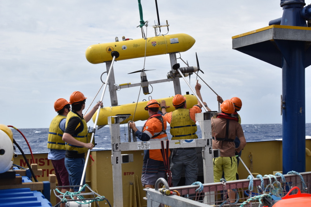
Deployment of the Autonomous Underwater Vehicle (AUV) Sirius from TV Bluefin the Australian Maritime College vessel. The AUV is an excellent tool for collecting high resolution down-ward facing imagery of seafloor habitats (Source: Kristy Brown, Institute of Marine and Antarctic Studies, University of Tasmania).
What did we learn?
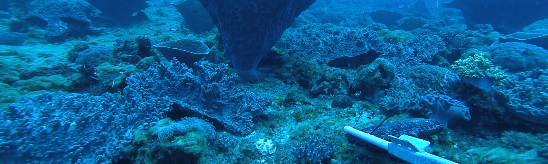
Our results revealed a complex seafloor on the shelf platform of each reef, characterised by mounds, ridges, planes and depressions. Ridges, mounds and planes observed on the inner shelf (20–50 m depth) were dominated by turfing macroalgae, cnidarian corals (hard reef building corals and soft leather corals) and bacterial mats. Whereas planes and ridges on the outer shelf (70–110 m) were dominated by black corals (branching and whip morphologies), interspersed among areas of coarse carbonate sand, turfing algae, hard corals, sponges and calcareous rhodoliths beds. These results are similar to seafloor habitats described on the shelves surrounding Lord Howe Island and Balls Pyramid, where mesophotic communities vary among inner-, mid- and outer-shelf areas.
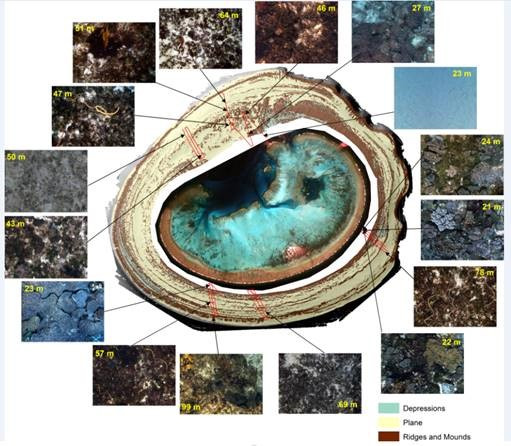
AUV images showing the range of benthic habitats across key seabed features at Middleton Reef shelf. Generally, ridges and mounds in mesophotic depths (20 – 110 m) are colonised by a dense cover of hard and soft corals, with planes characterised by a mix of barren sediments and moderate cover of turfing algae, with rhodolith beds in deeper areas toward the shelf edge. AUV track lines are shown in red. Source: Geoscience Australia.

Combined hard coral and algae habitat in 30 m depth at Elizabeth Reef. Source: Institute of Marine and Antarctic Studies, University of Tasmania.
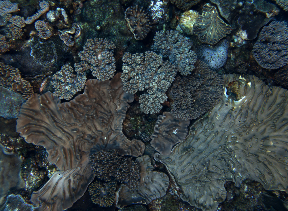
Ridge and mound features in water depths between 20 and 50 m at Elizabeth and Middleton Reefs are generally dominated by hard reef-building corals and soft leather corals. Source: Australian Centre for Field Robotics (University of Sydney), Integrated Marine Observing System (IMOS) Autonomous Underwater Vehicle Facility.
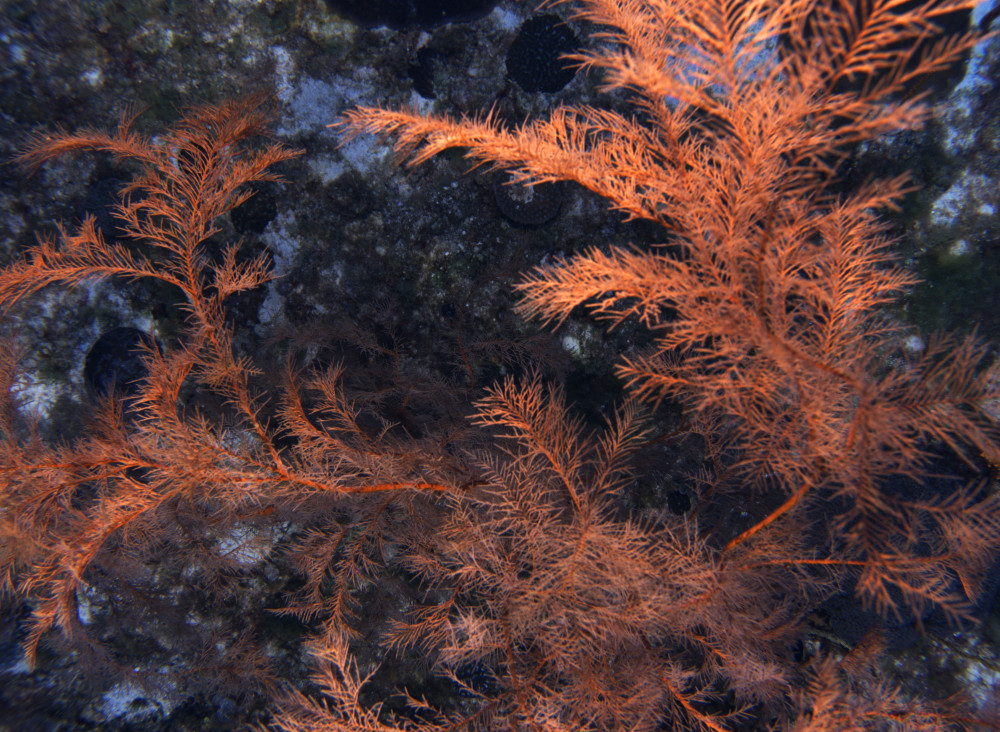
Ridge and plane features in water depths between 70 and 11m at Elizabeth and Middleton Reefs are dominated by black corals. Source: Australian Centre for Field Robotics (University of Sydney), Integrated Marine Observing System (IMOS) Autonomous Underwater Vehicle Facility.
Demersal fish were abundant across lagoon, inner shelf and mesophotic shelf habitats, with ~6200 individual fish recorded by stereo-BRUVs. This sample was also diverse, comprising 195 species from 36 families. Clear patterns in some trophic feeding guilds were evident across depths at both reefs. While scraping and browsing herbivore abundance decreased with depth, generalist carnivore abundance increased with depth.
Whether due to protection or isolation, or a combination of both, the reef systems surveyed here had a large proportion of top predators relative to continental shelf waters off eastern Australia. Elizabeth and Middleton Reefs remain a stronghold for populations of predatory fish and listed threatened species, including mature Black Cod and Tiger Sharks, and immature Galapagos Sharks.
Despite being limited by the truncated stereo-BRUV survey at Elizabeth Reef, initial survey results suggest a greater number of larger predators at the fully protected Middleton Reef than at Elizabeth Reef, which is open to fishing. Further sampling is required to determine whether this is a spatial pattern or one likely related to the extent of protection.
This is the first study to document mesophotic ecosystems on the shelf platforms of Elizabeth and Middleton Reefs. It demonstrated the utility of national standard tools such as AUVs and stereo-BRUVs to sample areas not readily accessible to divers, and the value of using the Hub’s best-practice survey design and sampling methods to ensure the comparability of survey data.
What next?
The shelf environments of each seamount have now been mapped in fine spatial resolution and sampled to better characterise seabed geomorphic features and associated habitats. For Middleton Reef, this mapping was completed for the entire shelf. Elizabeth Reef shelf remains only partly mapped and sampled, due to the early termination of the survey. Recommendations to complete and extend this work are included in the post survey report.
Quantitative baselines have now been established to support the monitoring of natural values and pressures at shallow and mesophotic depths. This contributes to the management of Lord Howe Marine Park and the 10-year management plan for the Temperate East Marine Parks Network (2018–2028). The new knowledge also provides an improved understanding of the representativeness of a key ecological feature in the Lord Howe Marine Park.
Recommendations for future research include:
- completing survey work at Elizabeth Reef to facilitate comparisons between management zones of the Lord Howe Marine Park;
- mapping and characterising deeper water habitats around each seamount reef to explore connectivity between shallow, mesophotic and deep seafloor habitats;
- repeat-sampling of invertebrates and fishes at each reef to examine changes through time in the context of management goals;
- using satellite derived bathymetry to map the geomorphology of shallower lagoon and inner shelf areas; and
- conducting further stereo-BRUVs surveys of fish communities to obtain population size estimates of key species such as black cod.