
Aerial view of a boat speeding near the Abrolhos Marine Park off the off the coast of Western Australia.
 by Parks Australia
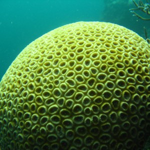
Still image of hard coral taken during underwater visual census surveys in the Houtman Abrolhos islands of Western Australia in 2008 as part of the Reef Life Survey program. The Reef Life Survey program is a volunteer network of highly trained divers, and is a product of the CERF Major Projects funding that facilitated a cost-effective citizen science contribution to inventory and monitoring of shallow water marine environments. The RLS program has been further facilitated within the NERP Hub, describing biodiversity patterns at a national and global scale, as well as providing critical baseline data from areas such as the Coral Sea Marine Park, from Ashmore Reef, the Great Barrier Reef,and other Australian Marine Park such as the Cod Grounds.
by Reef Life Survey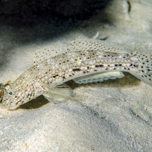
Istigobius decoratus, known as the Decorated Sandgoby is found on sand patches near reefs.
by Ian Shaw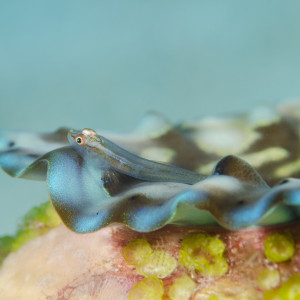
Pleurosicya mossambica also known as the toothy goby or the Mozambique ghost goby is found on many substrates, including corals, sponges, giant clams and seaweeds, and can vary colour according to the substrate.
by Ian Shaw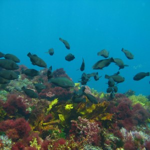
School of parrotfish over typical reef habitat of Houtman Abrolhos islands of Western Australia - taken as part of the global Reef Life Survey dataset. The Reef Life Survey program is a volunteer network of highly trained divers, and is a product of the CERF Major Projects funding that facilitated a cost-effective citizen science contribution to inventory and monitoring of shallow water marine environments. The RLS program has been further facilitated within the NERP Hub, describing biodiversity patterns at a national and global scale, as well as providing critical baseline data from areas such as the Coral Sea Marine Park, from Ashmore Reef, the Great Barrier Reef,and other Australian Marine Parks such as the Cod Grounds.
by Reef Life Survey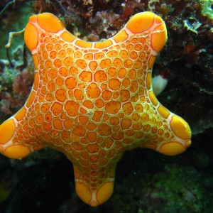
Still image of Pentagonaster dubeni (seastar) taken during underwater visual census surveys in the Houtman Abrolhos Islands of Western Australia in 2008 as part of the Reef Life Survey program. This volunteer network of highly trained divers is a product of the CERF Major Projects funding that facilitated a cost-effective citizen science contribution to inventory and monitoring of shallow water marine environments. The RLS program has been further facilitated within the NERP Hub, describing biodiversity patterns at a national and global scale, as well as providing critical baseline data from areas such as the Coral Sea Marine Park, from Ashmore Reef, the Great Barrier Reef,and other Australian Marine Parks such as the Cod Grounds Marine Park.
by Institute of Marine and Antarctic Studies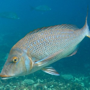
Still image of a Spangled emperor (Lethrinus nebulosus) taken during underwater visual census surveys in the Houtman Abrolhos Islands of Western Australia in 2008 as part of the Reef Life Survey program. This volunteer network of highly trained divers is a product of the CERF Major Projects funding that facilitated a cost-effective citizen science contribution to inventory and monitoring of shallow water marine environments. The RLS program has been further facilitated within the NERP Hub, describing biodiversity patterns at a national and global scale, as well as providing critical baseline data from areas such as the Coral Sea Marine Park, from Ashmore Reef, the Great Barrier Reef,and Australian Marine Parks such as the Cod Grounds.
by Institute of Marine and Antarctic Studies