
RV Challenger at the CSIRO wharf in Hobart ready for June 2012 Flinders Marine Park survey, with Baited under water video (shallow), Deep-water CSIRO Baited underwater video (topped with brightly coloured floats), plus the CSIRO Towed Video system. This NERP Hub cruise deployed baited underwater video and towed video over previously mapped seabed within the Flinders Marine Park to quantitatively determine the distribution of species and habitats within the shelf and upper slope of the Marine Park based on a GRTS-based statistical framework for spatially balanced sampling and inference.
 by Institute of Marine and Antarctic Studies, CSIRO
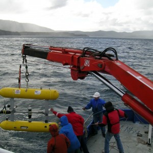
Launching an Integrated Marine Observing System autonomous underwater vehicle in Flinders Marine Park.
by Institute of Marine and Antarctic Studies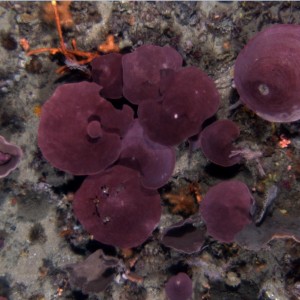
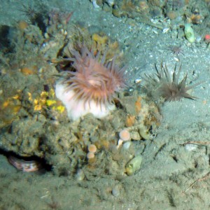
A still image of the benthos taken from an AUV in the Flinders Marine Park.
by Institute of Marine and Antarctic Studies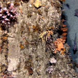
Still image from AUV of a mid-shelf reef ledge at 60 metres depth in the Flinders Marine Park showing lobster antennae, butterfly perch (both associated with the ledge feature), sponges and the usual biogenic matrix.
by IMOS, Institute of Marine and Antarctic Studies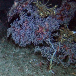
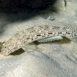
Istigobius decoratus, known as the Decorated Sandgoby is found on sand patches near reefs.
by Ian Shaw
A still image of a killer whale (Ocinus ocra) caught on camera during a BRUV deployment in a canyon-head incision of the shelf edge within the Flinders Marine Park (depth of 160 metres). The video shows numerous stripey trumpeter and a large rock lobster attracted to the bait before a killer whale passes overhead, scattering the trumpeter, who then turn and follow the whale. This illustrates the likely hot spot of productivity associated with such canyon-head upwelling areas, that is a focus for top predators like killer whales, and piscivorous fish such as stripey trumpeter.
by Institute of Marine and Antarctic Studies
A still image from video showing a Mako shark approaching BRUV deployed at the shelf edge near a canyon-head incision (depth of 140 metres). This is an example of the range of species attracted to BRUV's, and the potential of the canyon-head incision areas to be productivity hotspots, targeted by top predators like mako sharks, seals and killer whales.
by Institute of Marine and Antarctic Studies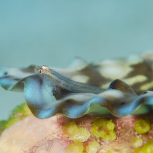
Pleurosicya mossambica also known as the toothy goby or the Mozambique ghost goby is found on many substrates, including corals, sponges, giant clams and seaweeds, and can vary colour according to the substrate.
by Ian Shaw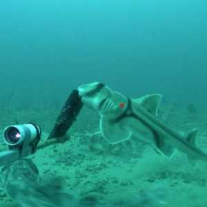
A still image of a Port Jackson shark (Heterodontus portusjacksoni) attracted to a BRUV in the Flinders Marine Park. Port Jackson sharks are well known to most divers and fishermen in southern Australia, where they commonly occur near the seafloor foraging on bottom dwelling invertebrates at night and returning to rocky caves and ledges to rest during the day. The spirally flanged egg cases of these creatures can also be observed wedged into reef crevices, where the young develop over a period of a year before hatching.
by Institute of Marine and Antarctic Studies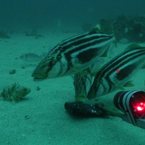
A still image taken from BRUV video (depth 160 metres) to illustrate the potential for stripey trumpeter to be a key indicator species within the Flinders Marine Park, and the extent that canyon-head incisions in the shelf in this Marine Park are productivity hotspots that are actively targeted by stripey trumpeter. Presumably the bait fish species attracted to the hotspot are a significant source of food for the piscivorous trumpeter, and the exposed deep-water reef system at the canyon head appears to provide optimal habitat for the trumpeter. Upwelling (or downwelling) curents at the canyon head are thought keep the deep reef systems from being buried in sediments.
by Institute of Marine and Antarctic Studies
A typical AUV image showing mid-shelf reef ledges within the Flinders Marine Park (depth 60 metres). This image indicates the sedimentary rock type that appears to form the majority of the reef habitat in the cross shelf region of this part of the coastal zone. Of particular note is the clear iron-rich nature of this particular outcrop. Also of note is that such overhanging reef-ledges are a typical characteristic of the shallow dipping sedimentary rock type in this area, reflecting bedding planes between the sedimentary layers. While they are a characteristic feature, such "ledges" only represent a very small fraction of the overall mapped "reef" habitat yet are likely to be most important for many of the fish species and lobsters that need the ledges as habitat. The remaining reef area appears to be very flat low-profile reef with little refuge space available.
by IMOS, Institute of Marine and Antarctic Studies