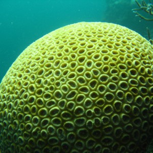
Still image of hard coral taken during underwater visual census surveys in the Houtman Abrolhos islands of Western Australia in 2008 as part of the Reef Life Survey program. The Reef Life Survey program is a volunteer network of highly trained divers, and is a product of the CERF Major Projects funding that facilitated a cost-effective citizen science contribution to inventory and monitoring of shallow water marine environments. The RLS program has been further facilitated within the NERP Hub, describing biodiversity patterns at a national and global scale, as well as providing critical baseline data from areas such as the Coral Sea Marine Park, from Ashmore Reef, the Great Barrier Reef,and other Australian Marine Park such as the Cod Grounds.
 by Reef Life Survey
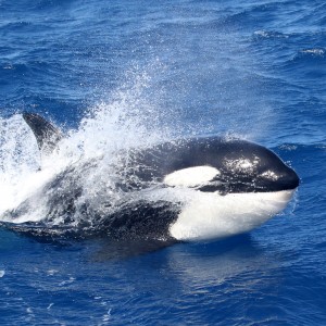
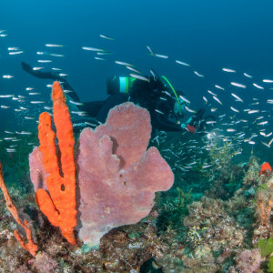
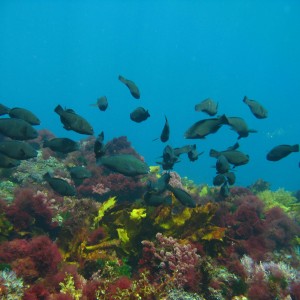
Clouds of temperate reef fishes drift over the sponge gardens in Geographe Marine Park.
by Rick Stuart-Smith
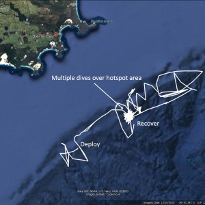
Google Earth image of the glider track in white from deployment to recovery. Glider tracks can look like "Mr Squiggle" drawings. This is because the gliders are propelled only by a buoyancy engine and their movement can be overpowered by strong ocean currents. In the latter part of the mission, the glider returned to the hotspot area where it did multiple dives before it was recovered.
by Paul Thomson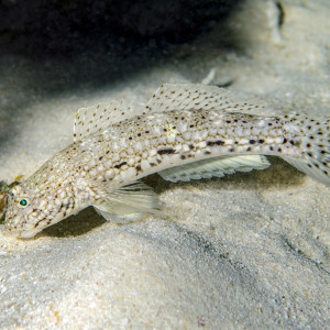
Istigobius decoratus, known as the Decorated Sandgoby is found on sand patches near reefs.
by Ian Shaw
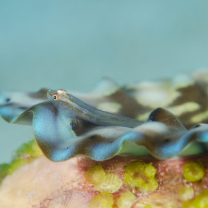
Pleurosicya mossambica also known as the toothy goby or the Mozambique ghost goby is found on many substrates, including corals, sponges, giant clams and seaweeds, and can vary colour according to the substrate.
by Ian Shaw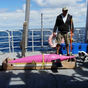
Dr. Paul Thompson from the University of Western Australia and the Integrated Marine Observing System prepares the Sea Glider for its mission. Mission preparation involves simulated glider dives on the deck prior to deployment to ensure all systems and sensors are operational.
by Paul Thomson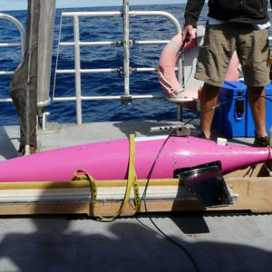
Dr. Paul Thomson from the University of Western Australia and the Integrated Marine Observing System prepares the Sea Glider for its mission. Mission preparation involves simulated glider dives on the deck prior to deployment to ensure all systems and sensors are operational.
by Paul Thomson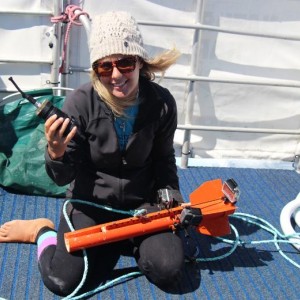
School of parrotfish over typical reef habitat of Houtman Abrolhos islands of Western Australia - taken as part of the global Reef Life Survey dataset. The Reef Life Survey program is a volunteer network of highly trained divers, and is a product of the CERF Major Projects funding that facilitated a cost-effective citizen science contribution to inventory and monitoring of shallow water marine environments. The RLS program has been further facilitated within the NERP Hub, describing biodiversity patterns at a national and global scale, as well as providing critical baseline data from areas such as the Coral Sea Marine Park, from Ashmore Reef, the Great Barrier Reef,and other Australian Marine Parks such as the Cod Grounds.
by Reef Life Survey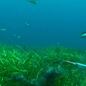
This image shows a seagrass bed in the Geograph Bay Marine Park, captured from a BRUVS survey. The seagrass beds of Geographe Bay are one of the largest meadows recorded in Australia, extending into water depths of up to 50 metres. Globally, seagrasses are believed to be the third most valuable ecosystem in the world. Seagrass beds prevent erosion of the sea bottom, reduce carbon dioxide out of the atmosphere and support diverse communities of marine animals such as invertebrates, fish, crabs, turtles, mammals and birds by providing food and shelter. Seagrasses enhance overall marine biodiversity and provide ecological functions and a variety of services to humans.
by Curtin University - Fish Ecology Laboratory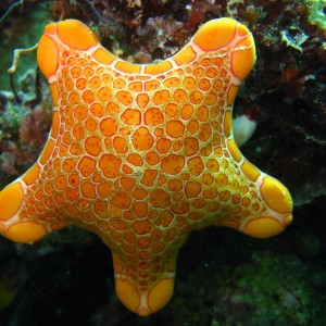
Still image of Pentagonaster dubeni (seastar) taken during underwater visual census surveys in the Houtman Abrolhos Islands of Western Australia in 2008 as part of the Reef Life Survey program. This volunteer network of highly trained divers is a product of the CERF Major Projects funding that facilitated a cost-effective citizen science contribution to inventory and monitoring of shallow water marine environments. The RLS program has been further facilitated within the NERP Hub, describing biodiversity patterns at a national and global scale, as well as providing critical baseline data from areas such as the Coral Sea Marine Park, from Ashmore Reef, the Great Barrier Reef,and other Australian Marine Parks such as the Cod Grounds Marine Park.
by Institute of Marine and Antarctic Studies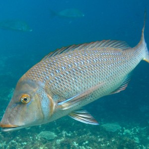
Still image of a Spangled emperor (Lethrinus nebulosus) taken during underwater visual census surveys in the Houtman Abrolhos Islands of Western Australia in 2008 as part of the Reef Life Survey program. This volunteer network of highly trained divers is a product of the CERF Major Projects funding that facilitated a cost-effective citizen science contribution to inventory and monitoring of shallow water marine environments. The RLS program has been further facilitated within the NERP Hub, describing biodiversity patterns at a national and global scale, as well as providing critical baseline data from areas such as the Coral Sea Marine Park, from Ashmore Reef, the Great Barrier Reef,and Australian Marine Parks such as the Cod Grounds.
by Institute of Marine and Antarctic Studies
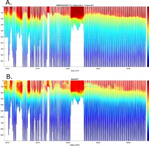
This figure shows (a) seawater temperature and (b) seawater salinity from the surface to 1000 metres depth during the Bremer Bay canyon glider mission. Patterns of seawater temperature and salinity (and therefore density) can reveal a lot about the structure of the ocean currents in a region. This figure shows relatively warm, eastward flowing Leeuwin current water down to about 200 metres depth, which overlays colder water of the Flinders Current and Antarctic Intermediate Water.
by Paul Thomson