Collecting scientific data in marine parks can be a lot of fun (if you don't get sea sick), but it requires a lot of hard work, planning and time. Distributed around the entire continent, and including some external territories such as Norfolk Island, Australian Marine Parks cover a total area of about 2.7 million square kilometres. The marine parks include waters from 3 nautical miles out to 200 nautical miles from the coastline, and down to depths of 6000 metres. Many of these parks are extremely remote, and can take several days to reach on a boat.
In such varied environments of such size, a range of different tools are used by scientists to conduct research and collect data. These fall into two main categories:
Remote sensing involves collecting information about what exists in a given area from a distance, usually using light, sound and other physical properties, and without making physical contact with the sea floor. In situ data collection involves using an instrument to examine something by physically touching or manipulating it.
Although a suite of standard technologies and instruments exist to monitor the marine environment, there are still numerous different ways in which these can be used to aquire data. This means that sometimes data from different areas are not directly comparable, reducing the usefulness of information available to managers.
In an effort to establish a nationally consistent approach to marine data acquisition, the NESP Marine Biodiversity Hub has developed a suite of field manuals that contain information on survey design, pre-survey planning, gear deployment and retrieval, and data management. These manuals are designed to aid in effective coordination across the marine science and observing community, and promote a standard national approach to monitoring our marine environment.
Remote Sensing
Acoustic - AUV - ROV - satellite imagery - towed video - sub bottom profiler
Acoustic surveys
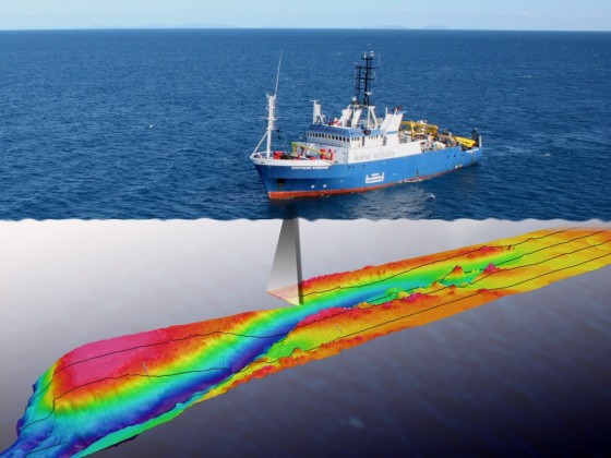
Acoustic surveys use sound to map the depth and topography of the seafloor. An acoustic profiler, either attached to the hull of a vessel or towed behind it, sends out a soundwave (or ‘ping’) at regular intervals. This soundwave travels through the water, and upon hitting the seafloor it is reflected back to the boat and the acoustic profiler. The return signal has different properties than when it was originally sent out, and these properties, with reference to existing field data, can be used to build a picture of the seafloor, including:
- how hard it is
- if it is made of sediments or rock
- if coral or seaweed are present.
The time between sending and receiving the soundwave can be used to calculate the depth (bathymetry) of the seafloor, and generate bathymetric (topographic) maps. There are different types of acoustic survey systems, and the most commonly used to map the seafloor are singlebeam, multibeam and side-scan sonars.
Autonomous Underwater Vehicles (AUV)
Autonomous underwater vehicles (AUVs) are untethered, battery-powered robots under the control of a computer on board a vessel. Looking much like a torpedo, they are used to collect still, video and acoustic imagery of the seafloor, while simultaneously collecting information on water conditions such as temperature, clarity, salinity, chlorophyll content and turbulence. Once deployed, AUVs follow pre-programmed ‘flight paths’ underwater at speeds of up to 4 knots, and on completion of the survey will return to a ‘pick-up location’ for retrieval and data download. They can stay beneath the surface for just a few hours, or up to several days.
AUVs are useful because they can reach shallower water than boats, and deeper water than divers. They provide water profiles and imagery of the seafloor over large areas, at closer proximities and higher resolutions than is possible from other similar ship-borne remote sensing equipment.
AUV surveys were recently used in the Tasman Fracture Marine Park to characterise the benthic biota of the shelf reef systems (Monk et al., 2016). The photographic imagery captured by the IMOS AUV facility Sirius showed an abundance of brittle stars and a dominant cover of soft corals, which is different to the sponge-dominated habitats that are more typically found at these depths (80–130 metres) in cool-temperate waters. This invertebrate assemblage is also markedly different to those recorded in previous AUV surveys in the Huon, Freycinet and Flinders marine parks, and demonstrates that each marine park contains unique biotic communities.
Remotely Operated Vehicles (ROVs)
A remotely operated vehicle (ROV) is an underwater robot tethered to a vessel and operated by an on board crew. Equipped with a video camera, still camera and lights, ROVs can transmit live footage back to the boat via a group of cables called the umbilical. Many ROVs also have manipulator arms for retrieving samples, sensors to record temperature, light, depth and salinity, and other sampling equipment and navigation systems. ROVs can access areas of the ocean that divers cannot reach, and are important for conducting scientific research in the deep ocean (down to 11 kilometres) and beneath ice sheets.
ROVs have been used to collect information on the seafloor type, biota and geomorphology of Osprey Reef in the Coral Sea (Beaman et al., 2016). In 2009 the Deep Down Under expedition deployed an ROV with a manipulator arm to collect samples of biota and rocks down to 787 metres, discovering species of glass sponges that were previously unknown to science. The ROV also collected over five hours of video imagery, revealing distinct depth-related zones with the species of coral and sponges observed below 450 metres believed to be unrelated to those occurring in shallow, warmer waters.
Satellite Imagery
Satellite images are pictures of the earth’s surface taken from satellites that orbit the earth, typically from between 500 to 800 kilometres above the surface. Different satellites take images at different resolutions – from 0.46 metres (DigitalGloge Satellites) to 1 kilometre (SPOT satellites) – and in different formats. For marine applications these images can be used to collect data on ocean properties such as sea surface temperature, sea surface height, ocean currents and chorophyll-a content. In shallow waters they can also be used to map areas of reef and sediment habitats.
Towed video
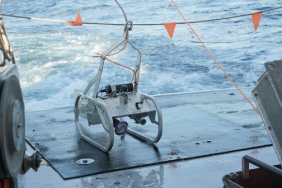
Towed video systems allow scientists to capture imagery of the seafloor over large areas down to 200 metre depths. A video camera mounted on a steel frame is towed behind a boat on a cable for a given length (a transect) and at a fixed speed. The cable allows on-board personnel able to observe the video in real-time, and to ensure safe navigation of the camera.
In addition to the video, still images are taken at regular intervals. The footage is later analysed to record species composition and distribution, habitat types and biodiversity. In any one study it is common to run several transects, and in this way towed video systems can quickly and easily gather data over large areas of the marine environment and generate a permanent record of observations for later analysis.
Towed video has recently been used in the Oceanic Shoals Marine Park to better understand biodiversity distribution in this region (Nichol et al., 2013). It was found that although low-relief areas of the continental shelf within the reserve supported relatively low abundances of macrobenthos, prominent seafloor features such as banks, pinnacles, ridges and terraces appeared to be biodiversity hotspots, with high diversity and abundance of sponges, corals and fish species observed. The high number of these prominent seafloor features in the Oceanic Shoal Reserve demonstrates the importance of this park for species biodiversity.
Sub-bottom profiler
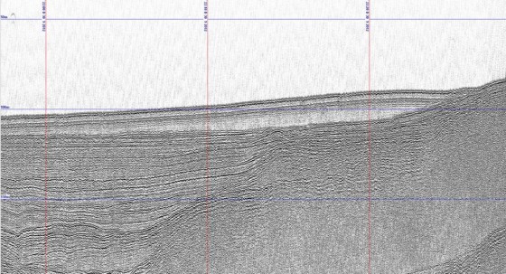
Sub-bottom profiling systems use sound to identify the layers and structure of the rock or sediment beneath the seafloor. Much like other acoustic survey techniques (e.g. multibeam sonar), sub-bottom profilers are mounted onto the hull of a vessel, and send out a soundwave at regular intervals. Parts of this soundwave will reflect off the seafloor, while other parts penetrate it and are reflected off rock and sediment layers beneath. The strength of the return signal depends on how soft or hard the subsurface layers are, and this builds a 3D picture of the seafloor, much like looking at a slice of layered cake. The time taken for the reflected signal to return to the ship can also be used to determine the depth of each of the layers. Sub-bottom profiling is useful for hydrographic surveys, determining sub-surface geology and assessing the processes that have influenced observed habitat types.
Sub-bottom profiles in several locations within the Oceanic Shoals Marine Park were able to penetrate more than 100 metres below the seafloor, and revealed bank features partially buried by soft sediments as well as ancient channel systems (Nichol et al., 2013).
In situ surveys
BRUVS - sleds - grabs/cores - SCUBA - trawls
Baited Remote Underwater Video Station (BRUVS)
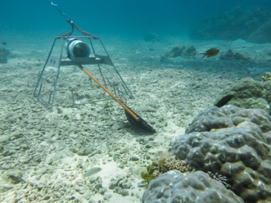
Baited remote underwater video stations (or BRUVS) are systems that work by using bait to attract and record fish on video. They are usually mounted above the seafloor on a tripod-like structure, and consist of small inexpensive video cameras in simple underwater housings with a mesh bag of fish bait held in front at the end of a steel arm. The cameras capture footage of fish attracted to the bait, as well as those that are just swimming past, and is later analysed to identify and describe the characteristics of the recorded fish assemblages, such as species, abundance, size and population structure.
BRUVS are a low-impact sampling technique, and are particularly useful in observing fish in hard-to-reach areas, deep and dangerous waters inaccessible to divers, and at night. They are also advantageous because they can be deployed in fleets over large areas, and record shy species such as sharks, rays and snakes that normally avoid scuba divers and towed videos. If two cameras are mounted at the same time in stereo-pairs they allow precise estimates of length and biomass.
BRUVS are a commonly used survey technique. A research project in Geographe Bay Marine Park sought to assess the distribution and characteristics of key habitat types and their associated benthic invertebrate and vertebrate communities (Lawrence et al., 2016). The survey included 150 BRUVS drops across the marine park in 2015, and preliminary analyses indicated that fish assemblages differ by depth and habitat (seagrass, reef or sand). Analysis of the habitat type in the BRUV footage also showed the reserve contains one of the largest continuous seagrass beds recorded. Tim Langlois of University of Western Australia has developed an interactive mapping tool to explore where BRUVs data exists around the world.
Benthic Sleds and bottom trawl
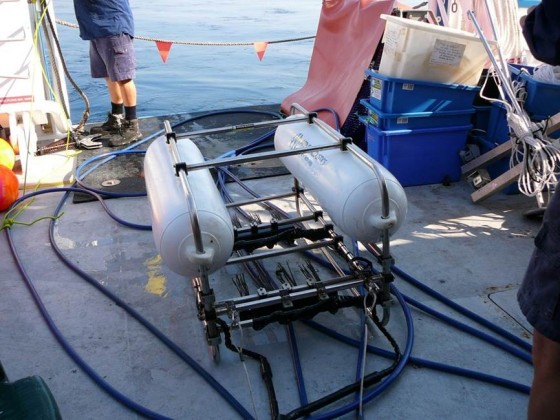
Benthic sleds and bottom trawls are designed to collect plants and animals living on top of the seafloor (the epibenthos). Both devices use nets towed along the seafloor to collect the organisms, however while a bottom trawl uses a free net with a steel frame to ensure it stays open, sleds consists of a steel frame mounted on a pair of ski-like runners that anchors the net to the seafloor. These systems are deployed from a vessel, and slowly towed along the seafloor for a given length, before being winched back to the boat for analysis. A mechanical door at the mouth of the nets prevents the samples washing away through turbulence as the device is retrieved. Benthic sleds are better suited to collecting sedentary and attached (sessile) organisms, while bottom trawls are more successful targeting mobile organisms.
While these survey methods use destructive sampling (removing organisms from the environment), they are used with care and sparingly so that impacts on the surrounding environment are minimised.
Sediment grabs and corers
Sediment grabs and corers are used to sample the seafloor and organisms that live on or just below it. There are two main types of sediment samplers – grabs and corers. Both grabs and corers are deployed off a boat and dropped to the seafloor. The grab scoops up the sediment, disturbing and mixing sediment layers and any organisms in it. A sediment corer works by boring a cylindrical tube into the sediment, and uses caps to seal it either end. Corers return an intact sample that represents the top 10 centimetres – 5 metres of sediment and benthos.
Grabs and corers are usually used in sandy and muddy areas, however they can be used over pebbles and cobble surfaces as well. There are many different types of grab and core samplers, and the best one depends on the habitat type, depth, the research question and vessel capabilities.
On a month-long voyage to seven Australian marine parks on the east coast of Australia in June 2017, sediment corers were used to sample for deep-sea microplastics in the muds of the Australian abyssal plain (2500–4000 metre depths; Lewis 2017). Microplastics refer to tiny plastic particles typically less than 5 millimetres, and results from analysis of these samples will be compared to those of surface net trawls for microplastics taken from the same sites to help us understand the extent of microplastic accumulation in the deep ocean.
SCUBA diving
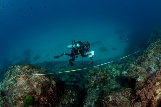
There are many other different types of surveys that are carried out by divers in the water. Divers collect data on a range of biological and physical attributes, including species types, abundance and size distributions, habitat types, and the structure and composition of the seafloor. Some common methods used to conduct these surveys are taking photographs and performing visual counts and estimates along a transect or within a quadrat.
A transect is a survey line of a set length which divers swim along, recording the desired information. Quadrats are generally steel frames of a given size, usually up to 1 metre squared, which are placed on the seafloor to define the area within which to collect the data. In any given survey divers will collect data from multiple transects and/or quadrats, and the results are combined and compared. The type of survey that is carried out will depend on what is being studied, the information required about it, and the resources available to collect it.
Reef Life Survey is a long-term marine life monitoring program that uses trained volunteer SCBUA divers to record the abundance of all conspicuous species observed on reef systems across Australia and the world. Data generated by RLS divers at 160 sites over 17 reef systems in the Coral Sea has been analysed and demonstrated that this region in home to a unique assemblage of marine species in Australian waters, more similar to reefs off the Pacific Island than to those of the Great Barrier Reef (Edgar 2015).
Plankton Trawls
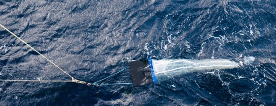
Plankton are small and microscopic plants and animals that can’t swim, and instead drift or float in the ocean. They include diatoms, small crustaceans and the eggs and larval stages of larger organisms. Plankton trawls tow long funnel-shaped nets kept open by steel doors to collect samples of the plankton communities. Net mesh sizes can be changed to target different sized plankton species. The plankton collect at the tip of the net, in a small cylinder called the cod end, which can be sealed off once collection is complete. Plankton trawls are considered one of the simplest and most cost-effective ways to collect information of the types, density and biomass of plankton in a given pelagic area. This same method can be used to collect and monitor levels of microplastics in the water column.
References
Monk, J., Barrett, N., Hulls, J., James, L., Hosack, G., Oh, E., Martin, T., Edwards, S., Nau, A., Heaney, B. and Foster, S. (2016) Seafloor biota, rock lobster and demeral fish assemblages of the Tasman Fracture Commonwealth Marine Reserve region: Determining the influence of the shelf sanctuary zone on population demographics. A report to the National Environmental Research Program, Marine Biodiversity Hub. Published by the University of Tasmania.
Beaman, R., Bridge, T., Luter, C., Reitner, J. and Worheide, G. (2016) Spatial patterns in the distribution of benthic assemblages across a large depth gradient in the Coral Sea, Australia. Marine Biology 46 (4), 795-808. DOI: 10.1007/s12526-015-0434-5.
Nichol, S., Howard, F., Kool, J., Stower, M., Bouchet, P., Radke, L., Siwabessy, J., Przeslawski, R., Picard, K., Alvarez de Glasby, B., Colquhoun, J., Letessier, T. and Heyward, A. (2013) Oceanic Shoals Commonwealth marine reserve (Timor Sea) biodiversity survey: GA0339/SOL5650 - Post survey report. Record 2013/38. Geoscience Australia, Canberra.
Lawrence, E., Hovery, R., Harvey, E., Kendrick, G., Hayes, R. and Williams, S. (2016) Application of NERP Biodiversity Hub survey methodology to geographe Commonwealth Marine Reserve -final report. A report to the National Environmental Research Program, Marine Biodiversity Hub.
Egdar, G., Ceccarelli, D. and Stuart-Smith, R. (2015) Reef Life Survey assessment of Coral Sea biodiversity in the Coral Sea. Report for the Department of the Environment by the Reef life Survey Foundation Inc. and Institute of Marine and Antarctic Studies.


