
Where
Mewstone region, northeast Tasman Fracture Marine Park
Who
When
2014–2016
Why
The Tasman Fracture Marine Park is unique in that it is the only marine park in the Southeast Network that includes a Marine National Park zone, completely prohibiting fishing activities in 692 square kilometres of ocean on the continental shelf. Despite being protected for over 7 years, little is yet known about what exists beneath the waves in this area or to what extent zoning arrangements influence the benthic habitats in this region.
How
In a two-phase expedition scientists used a combination of survey techniques to gather information about the physical and biological attributes of the communities both within and outside of the Marine National Park zone. Multibeam sonar was used to map the seabed in the sanctuary zone, and the IMOS AUV Sirius photographed nearly 150 different types of attached invertebrates on reefs in this region. BRUVS stationed on the seabed were used to survey the fish assemblages, and research lobster pots were deployed to investigate the abundance and distribution of lobsters, a highly targeted fisheries species.
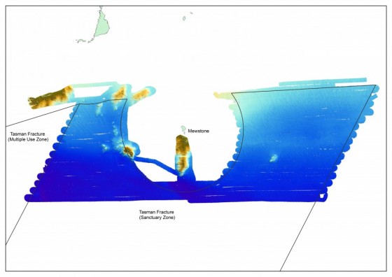
A map of the Tasman Fracture Marine National Park Zone, surrounding the Mewstone, that was mapped during the survey in 2014.
What did we learn?
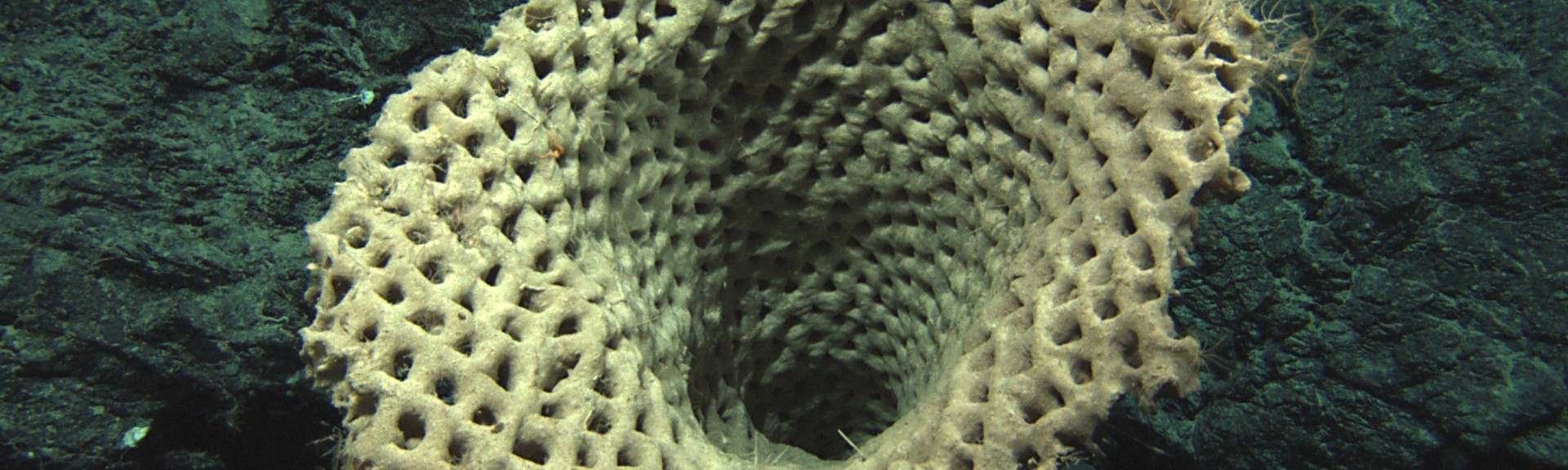
Several reef systems were discovered in the north of the mapped region, extending to depths of 140 metres. The AUV imagery showed a dominance of bryozoan and soft coral assemblages, with an unusually high number of brittle stars. This is unusual for deep reefs in southern Australia which are more typically dominated by sponges. Brittle stars, and to some extent soft corals, are detritivores, and feed by scavenging small particles of organic waste (called detritus) that rain down from the more productive surface waters above. The dominance of these species in this ecosystem indicates that much of the food supply to this area is in the form of detritus. Analysis of the BRUVS footage counted 20,929 individual fish representing 47 different species from 33 families. The most abundant species included ocean reef perch, butterfly perch, jack mackerel, splendid perch, rosy wrasse, cosmopolitan leatherjacket and red cod. Juvenile jackass morwong, previously thought to grow up in estuaries, were also observed in high numbers. The abundance of many commercially targeted species of fish and lobsters were found to be higher within the Marine National Park Zone.
What next?
This work has generated the first fine-scale bathymetric map of the region and has provided baseline data on the presence, abundance and distribution of reef-associated species. Researchers are interested in conducting regular sampling in this region with a more robust design to better understand the influence of protection on these species and the spatial variation in reef communities of the region. These data can also be compared to other neighbouring marine parks to gain a better understanding of how they differ, and the importance of maintaining a network of reserves in order to effectively conserve marine biodiversity.
Related data and publications
Monk, J., Barrett, N.S, Hulls, J., James, L., Hosack, G.R, Oh, E., Martin, T., Edwards, S., Nau, A., Heaney, B. and Foster, S.D. (2016). Seafloor biota, rock lobster and demersal fish assemblages of the Tasman Fracture Commonwealth Marine Reserve Region: Determining the influence of shelf sanctuary zone on population demographics. Report to the National Environmental Research Program, Marine Biodiversity Hub. Published by the University of Tasmania.
For more information please contact marinescience@environment.gov.au.