
Where
Hunter Marine Park, Special Purpose Zone (Trawl). Sampling was undertaken on the inner shelf primarily in depths between 80 and 110m but the shallowest site at Outer Gibber was in 27m.
Who
Dr Joel Williams (NSW Department of Fisheries), Dr Tim Ingleton (NSW Department of Planning, Industry and Environment), Dr Neville Barrett (University of Tasmania).
When
Surveys were completed in the autumn and spring from 2016 to 2020.
Why
The Hunter Marine Park is located within the Temperate East Marine Parks Network. Shelf rocky reef was identified as a Key Ecological Feature of the Hunter Marine Park. To better understand where these reefs occur and what lives on them, we needed to map and survey the seabed habitats and associated species using various technologies. With sufficient sample sizes, we can begin to establish baselines that can be used to detect future changes in habitat and fish on these rocky reefs into the future.
How
The seabed was mapped with multibeam echo sounder that provides bathymetry or depth data, as well as backscatter data that provides information on the hardness or seafloor type. Towed video was used to ground truth the multibeam echo sounder and provide data on habitat types. Stereo baited remote underwater videos (Stereo-BRUVs) were used to sample the fish assemblages and provides data on abundances, lengths and biomass of fish. All this data and information can be used to make habitat maps and species distribution maps. For this study we follow the standard operating procedures that are presented in the NESP Marine Biodiversity Hub Field Manuals for sampling in Australian waters.
What did we learn
Approximately 125 km2 of seabed was mapped inside the Hunter Marine Park. These data were used to provide high resolution bathymetry maps for key areas of the Hunter Marine Park inner shelf. We were able to identify approximately 6 km2 of rocky reef within the mapped area. The range of reef types are described in ‘landform’ feature terms as:
- a) low profile and b) low profile patch reefs generally in deeper mesophotic areas,
- rugose peak reefs in shallow water, and
- long, linear ridges in deeper water potentially associated with relic coastline.
Soft sediments feature as:
- flat low slope plains,
- platform/plateau plains and
- bedform plains or
- a trough, channel-shaped seabed landform offshore of Seal Rocks/Sugarloaf Point.
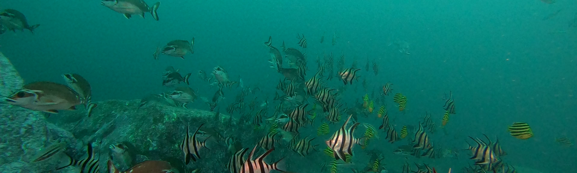
Towed video transects identified a range of benthic and pelagic plants and animals across depths of ~35 – 110 m. Imagery of shallow reefs (<50-60m) indicated benthic communities dominated by branching and turfing brown algae with encrusting and branching sponges, ascidians and sea whips. This reef was relatively high profile characterised by large boulders and or large blocks of consolidated reef. The deeper reef communities (60-110m) are restricted to blocky patch reefs surrounded by soft sediments or sediment veneered reefs. These communities were dominated by branching sponges, corals, and sea whips with symbiotic brittle stars. Large planar areas were dominated by soft sediments. In shallow waters the seabed had migrating sand waves and a few sea stars, but at depth the seabed was either flat and barren, covered in debris, contained animal burrows or had sparse coverage of erect tube worms.
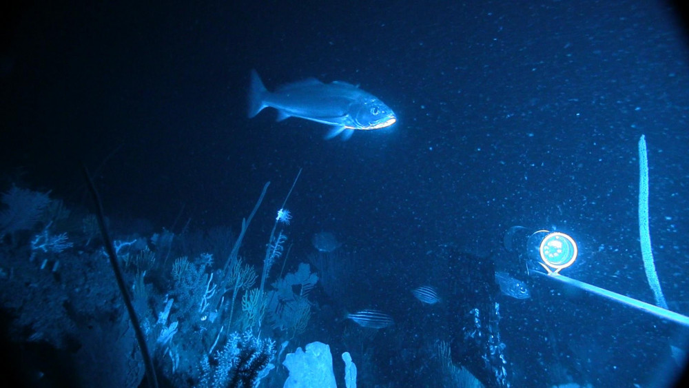
A teraglin, Atractoscion aequidens, swimming over diverse sessile invertebrate assemblage on rocky reef in 90m of Seal Rocks in the Hunter Marine Park. This still image was collected during the NESP Marine Biodiversity Hub stereo-BRUV surveys.
Stereo-BRUVs were used to estimate relative abundance and lengths of benthic reef fish. Over four surveys, 180 stereo-BRUVs were completed in three distinct locations associated with the MBES mapping.
- Broughton Island offshore, a patch of low profile and highly fragmented reef in 80-110 m of water sometimes consisting of large angular boulders
- Outer Gibber, a small but high relief reef in 35-60 m of water
- Seal Rocks Offshore, a low-profile reef system in 80-105m often interspersed or veneered with soft sediment.
In total, 112 species were identified during this study. Outer Gibber had the highest numbers of species on a single drop (n = 28). The reef systems in the Hunter Marine Park supported a large number of fishery targeted species, particularly pink snapper and blue morwong. Two threatened and endangered species were also recorded, white shark Carcharodon carcharias and grey nurse shark Carcharias taurus.
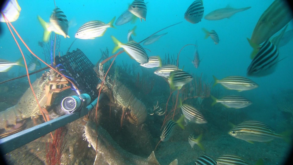
Eastern rock lobsters and fish aggregating around the bait in the BRUV at mesophotic reef (Sea Rocks) at 85 metres. This still image was collected during NESP Marine Biodiversity Hub BRUV surveys in the Hunter Marine Park.
What next
Mapping work indicated that further reef features are expected north of the existing Seal Rocks surveys and between Seal Rocks and Broughton coverages. Multibeam echo sounder surveys over unmapped areas in 140-200 m water depth and along the upper edge of the continental slope would also complement earlier surveys and help characterise seabed communities at the top of the continental slope. These areas should be considered a priority for future mapping effort within the park’s Special Purpose Zone, complemented with seabed and landform-type classification assessments.
Further quantitative analysis of the imagery collected from towed video will provide a better insight into the distribution of sessile invertebrates across the inner shelf of the Hunter Marine Park.
Once extra areas of reef are mapped it would be advisable to sample these areas with stereo-BRUVs and video surveys to increase the sample size of the baseline data and provide more statistically robust species distribution maps and estimates of abundances within the Hunter Marine Park.
Related data and publications
NESP Marine Biodiversity Hub report of this study - Mapping and characterising reef habitat and fish assemblages of the Hunter Marine Park.
A peer reviewed paper comparing the fish assemblages of the Hunter Marine Park with the inshore Port Stephen-Great Lakes Marine Park, Taking a deeper look: Quantifying the differences in fish assemblages between shallow and mesophotic temperate rocky reefs.
Other reports from this project and other Hunter Marine Park research:
Recreational fishing in Commonwealth waters
Fish assemblages on reefs in the Hunter Marine Park and adjacent waters
Field manuals for marine sampling to monitor Australian waters
Data from this study is open access and can found here:
Study data - Multibeam echo sounder: AusSeabed Marine Data Portal (ga.gov.au)
Study data - https://iar.environment.nsw.gov.au/dataset
Study data - Towed video: https://squidle.org/
https://iar.environment.nsw.gov.au/dataset/nesp-biodiversity-hub-nsw-dpie-hunter-marine-park-towed-video-imagery
Stereo-BRUV data is available from the GlobalArchive website: