
Where
Tasman Fracture Marine Park, South-east Marine Parks Network.
Who
The Institute for Marine and Antarctic Studies (IMAS), University of Tasmania; Australian Centre for Field Robotics, University of Sydney; Integrated Marine Observing System (IMOS).
When
Rock lobster potting and Baited Remote Underwater Video (BRUV) surveys were conducted between 18th and 21st March 2021; Autonomous Underwater Vehicle (AUV) surveys were conducted between 14th and 17th June 2021. Video and image annotation and statistical analyses were conducted at IMAS during 2021 and 2022.
Why
Surveys of the Tasman Fracture Marine Park in 2021 provided scientists and managers the opportunity to examine changes that occurred across the Marine Park and nearby reference areas over the 7 years since the initial surveys in 2014/15. A key focus was contrasting changes in the fully protected National Park Zone (NPZ) with those observed elsewhere in the park and in similar habitats adjacent to the park. This information is needed by Parks Australia to evaluate zone effectiveness and inform ongoing management actions.
Understanding how the biological communities inside the South-east Marine Park Network change through time provides crucial information about natural variability in communities and individual species, and how management measures such as protection from some human activities may be influencing these communities.
Ongoing monitoring of the South-east Marine Park Network using established scientific tools and methodologies allows reporting to the public about important changes across the network and can also broadly inform other interested sectors such as fisheries managers.
How
All survey work was underpinned by multibeam sonar mapping of the seafloor conducted by the Institute for Marine and Antarctic Studies and CSIRO in 2014 and 2019. Mapping allows the creation of high resolution 3-dimensional topographic depictions of the sea floor so that complex rocky reef features can be distinguished. These maps then allowed the targeting of survey effort to reef features that are more likely to provide habitat for species of interest such as fish, lobsters, and other invertebrates. Also, multibeam maps can be used to extract measures of habitat complexity that can be used in analyses of species distributions across the Tasman Fracture Marine Park.
Research lobster pots were deployed, which unlike commercial fishing pots, have closed escape gaps so that all size classes of lobsters are retained along with any bycatch. All lobsters caught were measured and their sex determined. All bycatch caught in pots was counted and fish species were measured. All lobsters, fish and other bycatch were returned to the water safely.
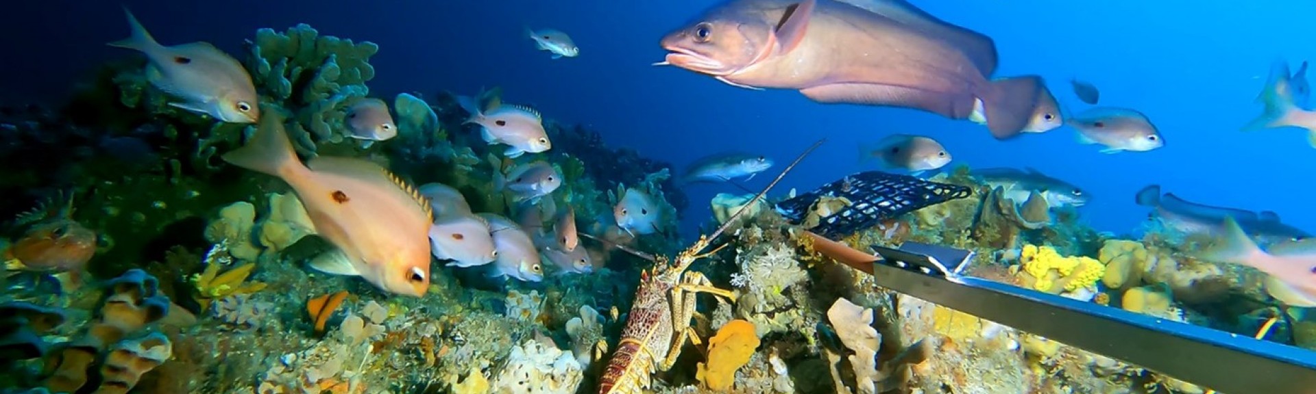
Baited remote underwater stereo video surveys use a metal frame that stereo video cameras are mounted to. A bait bag of crushed pilchards is also attached to attract fish in front of the cameras. The stereo cameras allow precise size measurements of fish to be taken from the video footage. An index of abundance for each fish species known as “MaxN” is calculated using the video frame with the highest number of that fish species. This ensures that fish aren’t double-counted when they enter or leave the frame.
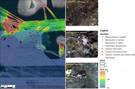
Map of handfish observed in AUV imagery across the Tasman Fracture Marine Park, along with potential species groupings.
AUV surveys in 2021 expanded markedly on those conducted in 2015, with extensive surveys in the National Park Zone, Muti-Use Zone and reference areas outside the Marine Park. The AUV “Sirius” navigates pre-determined transects along the seafloor while taking continuous photos was used. All imagery and annotations are available through SQUIDLE+.
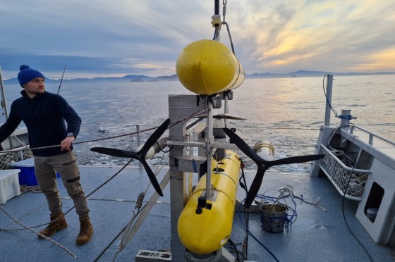
Autonomous Underwater Vehicle (AUV) "Sirius" ready for deployment.
What did we learn
The 2021 surveys reinforced the status of the Tasman Fracture Marine Park as a biodiverse and unique Marine Park within the South-east Marine Park Network. The seafloor communities were found to contain a high abundance and diversity of soft corals that have not been seen in similar abundance elsewhere in the South-east Marine Park Network. These diverse benthic communities provide habitat for an abundance of commercially important lobster and fish species (including Jackass morwong and striped trumpeter), as well as endangered or rare species such as handfish.
Example AUV image from the Tasman Fracture Marine Park National Park Zone showing octopus, ocean perch, sea fans, and sponges.
An increase in the abundance of lobster as well as a higher proportion of large lobsters was found between the two surveys, both inside and outside the NPZ. While on a habitat for habitat basis there were more large lobsters in the protected NPZ the increase in large lobsters in fished areas was notable. This indicates a strong rebuilding of lobster stock has occurred in the region, one likely underpinned by strong recruitment of juvenile lobsters in prior years combined with a reduced commercial fishing effort in these remote offshore waters over the survey period resulting from changing market demands. A general increase in the bycatch of conger eels and other important bycatch species across both fished and protected areas lends further evidence to a decrease in fishing effort and its impact on bycatch species.
While the 2014 survey found an increased abundance of several targeted and bycatch fish species in the NPZ relative to adjacent fished areas, this difference was no longer evident by 2021. As the NPZ is in a remote and usually inaccessible location it is not actively targeted by recreational fishers, hence at present, the fish assemblages in the NPZ are not expected to show an early response to protection from recreational fishing. Commercial fishers are the main users of this area, primarily to access lobsters but also with supplemental line fishing. Prior to the 2015 survey, it was likely that both line fishing by lobster fishers, and fish bycatch in lobster pots was a sufficient fishing effort to drive the observed difference between the NPZ and the adjacent fished areas at the time. With the marked decline in lobster fishing effort subsequent to 2015 (evident by lobster recovery in these areas) it is likely that both target and bycatch species have recovered sufficiently to reduce the difference seen between the NPZ and fished areas in 2021.
Of special scientific and public interest was the observation of a population of a significant number of rare and endangered species in both BRUV and AUV surveys. A pink handfish, not recorded in the wild for over 22 years was identified in BRUV footage.
A collar seahorse, not previously seen in Australian continental shelf waters, was recorded in BRUV footage. Following the pink handfish sighting, the AUV imagery was intensively examined for the presence of handfish. Overall, more than 70 individual handfish were recorded in the AUV imagery, providing a very unexpected result. While species identification using the AUV images is problematic due to the small size of handfish relative to the image size, it appears that there are at least 4 species present. Being the most southerly Marine Park, other than Macquarie Island MP, it seems that Tasman Fracture Marine Park may be providing critical habitat for these rare and endangered cool water species due to the presence of cooler water on the shelf seabed in this region relative to more nearshore coastal waters. Ongoing monitoring of the Tasman Fracture Marine Park and the important and endangered species inside the Park will enable Parks Australia to better understand the natural values within and how they are changing through time.
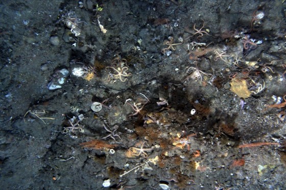
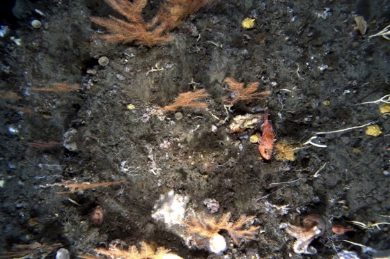
Example AUV image from the Tasman Fracture Marine Park National Park Zone showing brittle stars, bryozoans, sea fans, and sponges. There is also a handfish somewhere in there – can you spot it?
What next
These first two surveys of the TFMP have provided a comprehensive baseline description of the distribution and changes in communities, species and the size structure of important fish, lobster and non-mobile seafloor invertebrates. Future plans involve further surveys utilising similar methodologies to continue monitoring changes across this unique ecosystem.
Plans are also underway to conduct more extensive surveys of the handfish populations present in the Tasman Fracture Marine Park potentially using remotely operated vehicles and environmental DNA technologies to enable the differentiation of the species present and where they occur.
A PhD candidate is using the AUV imagery to undertake a more detailed analyses of the distribution of the dominant invertebrate species and how they have changed between the two surveys.
Related data and publications
BRUV highlight clips can be found here.
AUV transects can be found here.