Summary
A collaborative research voyage on the state-of the-art research vessel RV Investigator in 2018 explored Tasmania’s hidden seamounts (under-sea mountains). Extensive areas of deep-sea coral reefs supporting diverse communities were surveyed, mostly between 700 and 1500 metres below the sea surface. These seamount reefs represent a globally significant reference site to monitor recovery of deep-sea coral communities following the impacts sustained from bottom trawling in the 1990’s. We now better understand the biodiversity and distribution of these vulnerable ecosystems and their ability to recover from impacts such as a bottom trawling.
Where
Huon Marine Park and Tasman Fracture Marine Park off southern Tasmania
Who
A collaboration between the CSIRO, Marine National Facility, the National Environmental Science Program Marine Biodiversity Hub, Australian Museum, Museums Victoria, Tasmanian Museum and Art Gallery, National Institute of Water and Atmospheric Research (NZ), the University of Tasmania, University of the Sunshine Coast, and Parks Australia.
When
The survey occurred in November - December 2018
Why
Seamounts – undersea mountains which are frequently the remains of ancient volcanoes – are home to some of the world’s most biodiverse deep-sea coral communities. The corals themselves are typically slow-growing, fragile and may live for 100s, even 1000’s of years. They provide habitat and feeding areas for a wide variety of fishes and bottom-dwelling invertebrates such as sponges, crustaceans and molluscs. Individual seamounts can support areas of highly elevated biodiversity in the deep-sea.
A group of seamounts south of Tasmania (Figure 1) support coral communities that are rich by global standards. They rise several hundred metres above the seafloor with their summits reaching to depths of between 600 and 2,400 metres below the sea surface.
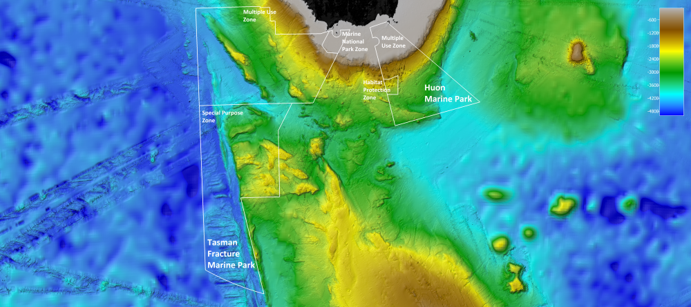
Figure 1: Tasman Fracture Marine Park and Huon Marin Park seafloor map CSIRO
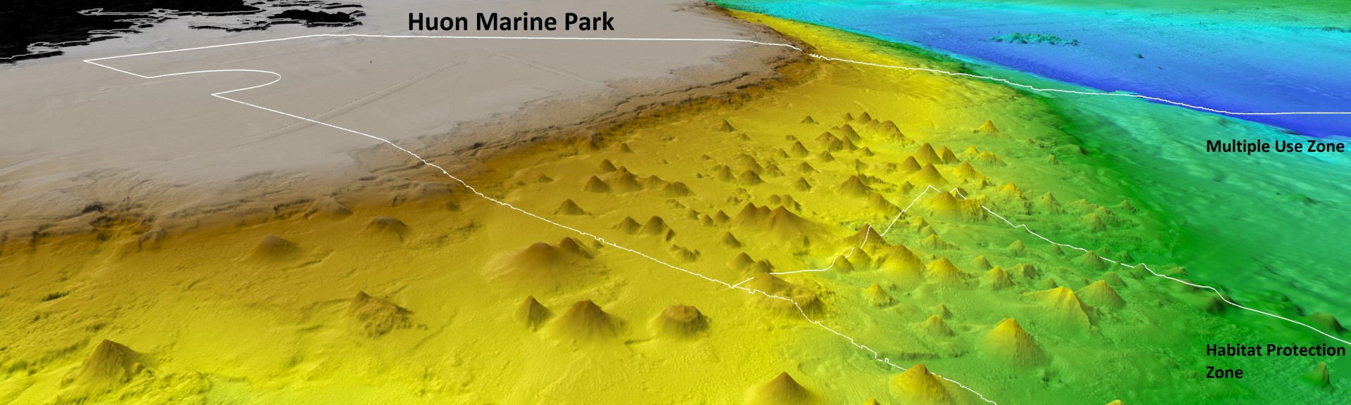
Seamounts may also support concentrations of fishes which draw the attention of commercial fisheries. Some, but not all, of the seamounts off Tasmania were fished for orange roughy using bottom trawls. Seamount coral communities are vulnerable to impacts from this method of fishing, but now Australian Marine Parks provide protection to a large number of seamounts – in the Tasman Fracture Marine Park and particularly in the Huon Marine Park (Figure 2).
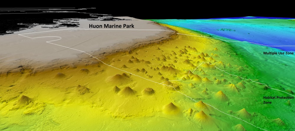
Figure 2: Huon Marine Park with Tasmanian Seamounts CSIRO
The recent survey provided an opportunity to compare communities found on seamounts inside and outside marine parks to better understand how historical fishing impacted their coral communities and whether there are signs of recovery (Figure 3). Such a comparison is enabled by two earlier surveys undertaken one and two decades earlier. The results from this work will provide world-first information on the recovery and ecological resilience of these fragile coral ecosystems to the Australian government and other national and international bodies.
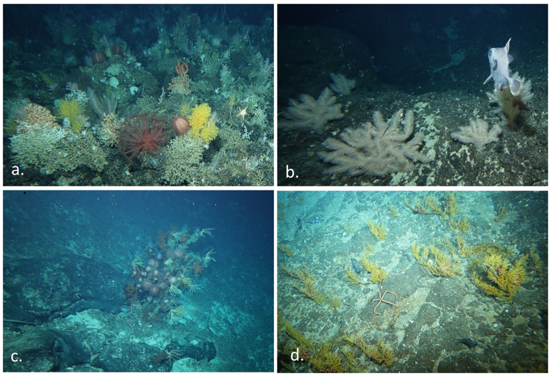
Figure 3: Octocorals, black corals and associated communities (a) Variety of octocorals associated with deep-sea coral reef on Seamount Z24 inside the Huon Marine Park (1,100 m); (b) Several colonies of the pinkish-gray octocoral Thouarella sp. with 3D branching morphology on Fang seamount inside the Tasman Fracture Marine Park (848 m); (c) A large black coral, Leiopathes sp. covered with associated urchins and un-stalked sea lilies on Hill K1 seamount inside the Huon Marine Park (1,399 m); (d) Abundant 2D Fan-shaped colonies of an unknown, yellow octocoral on Main Matt seamount inside the Tasman Fracture Marine Park (649 m). CSIRO
How
The deep-sea coral reef ecosystems were surveyed primarily with a CSIRO deep-tow camera system which carries video and still cameras, and a range of environmental sensors. Camera vision via a fibre-optic tow cable allowed a camera ‘pilot’ to see the seafloor in ‘real time’ and maintain the camera about 2 metres off the seabed along downhill transects from seamount peaks. A total of 147 transects were completed, each either 1 to 2 kilometres in length; these extended, collectively, from 500 to 1,900 m depths. Information on corals and other fauna is recorded from the images and plotted on maps.
In total, the survey generated more than 200 hours of video footage and 70,000 stereo image pairs along 200 kilometres of transect track.
To identify the biodiversity observed by cameras, researchers used a small sled to selectively collect biological specimens such as corals, sponges, brittle stars and crustaceans (Figure 4).
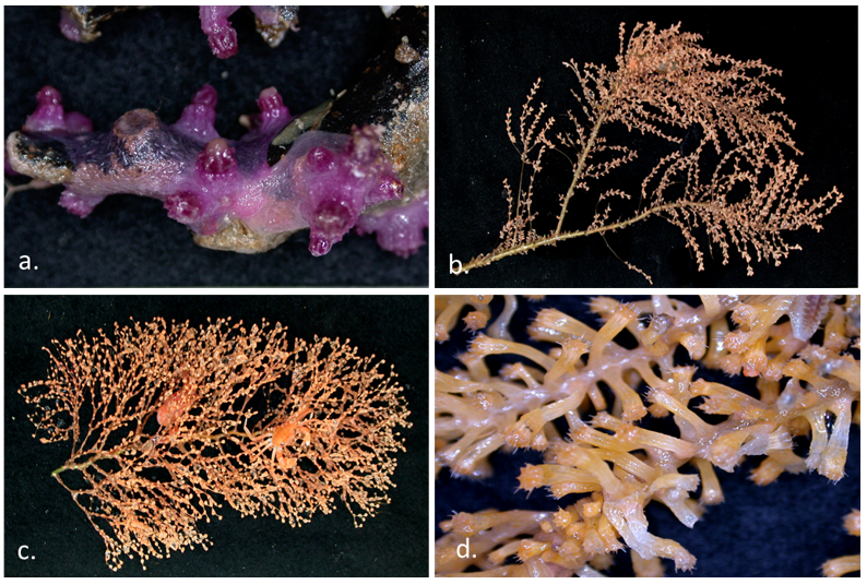
Figure 4: Specimens of new octocoral species (a) Encrusting, purple Trachythela sp. (b) An undescribed species of Thouarella sp. (c) A bottlebrush shaped Chrysogorgia sp. with crustacean associates (d) Polyps of a species of Acanthogorgia sp. (A, C, D: Punch’s Hill inside the Huon Marine Park; 1,093-1,124 m and B: Flat Matsuyker; 1,213-1,312 m) inside the Tasman Fracture Marine Park. CSIRO
A pair of CSIRO’s Deep Baited Remote Underwater Video Systems were used to collect data on fish communities at several seamounts within the marine parks. They were stationed in similar depths of 800-900 metres, one with bait and one without. The units were deployed approximately 200 metres apart. These systems used lights to record video in 40-minute samples separated by 30 minutes of darkness and covered 4 periods of the day (dawn, day, dusk and night).
What did we learn?
This research has improved our understanding of the distribution of deep-sea coral reefs and their associated communities off southern Tasmania. It confirmed that:
(1) a large proportion of seamounts found in southern Tasmania, including those with little or no sign of impacts from fishing, are protected within Australian Marine Parks, and
(2) that biodiversity is rich, for example, 199 soft coral species were recorded during this and earlier surveys with 52 of these being new (previously unknown) species.
The greatest relative abundances of two commercial fishes, orange roughy and oreo dories, were found on the Main Matt seamount within the Tasman Fracture Marine Park; the large numbers of orange roughy suggest Main Matt is now a refuge area, where trawling is no longer allowed.
An aggregation of the basketwork eel, Diastobranchus capensis, on Patience seamount within the Huon Marine Park is the only known spawning aggregation of any deep-sea eel in world oceans. This species is ecologically important, being a large-bodied scavenger; it had been negatively impacted in the past from considerable mortality in trawl catches.
Collectively, these characteristics identify the Tasman Fracture Marine Park and Huon Marine Park as very significant conservation assets for Australia.
The substantial body of knowledge gathered over two decades on evaluation of fishing impacts, monitoring changes in biodiversity, and possible early signs of recolonization in previously impacted areas, also identify the Tasman Fracture Marine Park and Huon Marine Park as a globally significant reference site to monitor recovery of deep-sea coral communities following the impacts of deep-sea trawling.
What next?
The high-resolution image data has allowed researchers to map the extent of globally significant deep-sea coral reefs and determine how much of the reef area lies within marine parks. It has also supported the long-term ecological monitoring of the coral communities and their rate of recovery from the impacts of commercial fishing.
The information collected will assist marine park managers to implement effective monitoring and management to enhance the long-term survival of deep-sea corals.
Future monitoring aims may include:
- Understanding the recovery trajectories of these deep-sea coral communities from the effects of bottom trawling.
- Assessing biological responses to climate change for deep-sea coral communities.
- Clarifying if the Tasman Fracture Marine Park and Huon Marine Park provide protection to the shallower stony coral species by sampling the shallow regions (< 950 m) of the Marine Parks.
- Mapping the extent of stony coral on rocky areas adjacent to seamounts to improve estimates of how much of the community has been protected and the likelihood of recovery, especially for the dominant species, Solenosmilia variabilis, which is primarily an asexually reproducing species.
- Developing methods to monitor changes in biomass of the basketwork eel aggregation on Patience Seamount – the only reported spawning aggregation of oceanic eels globally – predicting it will respond positively to protection by increasing in size, showing the benefits of protection in the Huon Marine Park.
- Evaluating the size of the orange roughy population on Main Matt Seamount may provide a useful index of stock recovery in any subsequent biomass assessment, and the role of the Tasman Fracture Marine Park in the recovery process.
Videos
Related data and publications:
Williams, A., Green, M., Untiedt, C., Maguire, K., Althaus, F., Alderslade, P. and N. Bax (2020). Status of deep-sea seamount coral and fish communities, and recovery from trawling, in the Tasman Fracture and Huon marine parks. Final Report to Parks Australia, June 2020, 75 pp.
Williams, A., Althaus, F., Green, M., Maguire, K., Untiedt, C., Mortimer, N., Jackett, C.J., Clark, M.R., Bax, N., Pitcher, C.R., and Schlacher, T.A. (2020). True size matters for conservation: deep-sea coral reefs are typically small and estimates of their size are remarkably robust to a method used to define them. Frontiers in Marine Science, 1-18. doi: 10.3389/fmars.2020.00187
Williams, A., Althaus, F., Maguire, K., Green, M., Untiedt, C., Alderslade, P., Clark, M.R., Bax, N., and Schlacher, T.A. (submitted). The fate of deep-sea coral reefs on seamounts in a fishery-seascape: what are the impacts, what remains, and what is protected? Frontiers in Marine Science